The levels of heat experienced upon the surface will be dependent upon the amount of energy, length of time energy is injected, and the size of the area. Timing for this heat to penetrate the surface is dependent upon the resistance in the rock and soils and the depth of the injection. Water will rapidly accelerate it between layers and rapidly move it towards the surface. Heat will bleed out and transfer from these regions following subterranean aquifers and structures, such as uplifts. Once surfaced, it will follow the territorial water sheds.
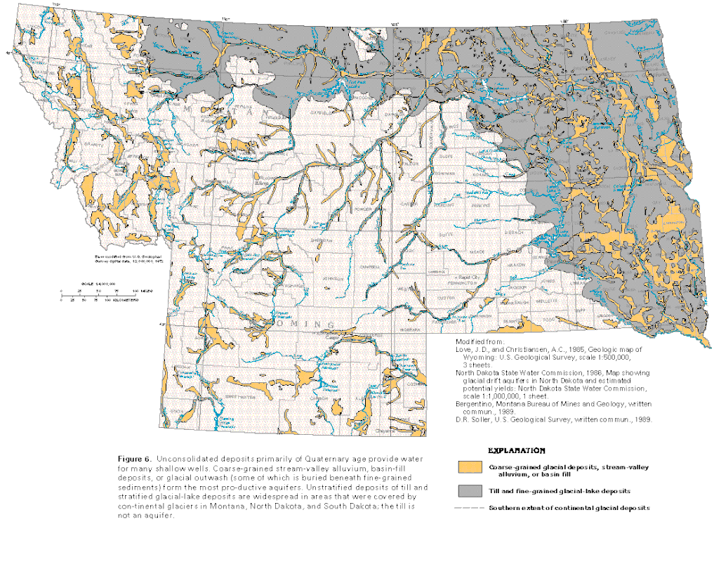
The USGS Geological Survey gives us insight into the subterranean regions and aquifers that form the Bakken Oil Shale region, also known as the Williston Basin.
The USGS Geological Survey gives us insight into the subterranean regions and aquifers that form the Bakken Oil Shale region, also known as the Williston Basin.
Production
Heating shale for 3 years prior to oil extraction was found to produce the best grade. Heating began on a limited and experimental basis in 2000, and later wide spread expansion in 2006, making 2009 the projected year for production to begin. Looking at the EIA Specifications for this region, Oil production hit 5 million barrels a month for the first time in July of 2008 and by August of 2010 had risen to 10 million barrels for the first time. Today, due to stagnant prices, production is remaining around 30 million barrels a month. Due to low oil prices in the 1980's many oil wells had become capped resulting in a reduction of oil production prior to the Bakken oil rush.
Using the figures at the EIA in the link above, North Dakota has produced 2,222,512,000 barrels of oil from 2009 through April of 2017. This is a 100-month period of time or an overall average of 22.225 million barrels per month since 2009. Using 5 million barrels as a potential base production we need to subtract this from overall production giving us 17.225 million barrels per month increase in production, or an overall increase of 1,722 million barrels since 2009. A brief history can be found here.
Using the figures at the EIA in the link above, North Dakota has produced 2,222,512,000 barrels of oil from 2009 through April of 2017. This is a 100-month period of time or an overall average of 22.225 million barrels per month since 2009. Using 5 million barrels as a potential base production we need to subtract this from overall production giving us 17.225 million barrels per month increase in production, or an overall increase of 1,722 million barrels since 2009. A brief history can be found here.
Volume and Size

The Great Pyramid of Egypt is estimated to be 5.75 million tons. "The kerogen content of “oil shale” ore can range from 10 to 60 or more gallons of oil per ton." Using a one barrel per ton average, 43 gallons, we can calculate that the total volume of rock liquefied, vaporized and extracted from the ground since 2009 is equal to 300 Great Pyramids being turned to dust so far. All of it needed heat at temperatures exceeding 650F.
At the current rate of 25 million barrels per month, we are currently extracting the equivalent of one Great Pyramid in this region alone every week, 52 every year.
Saturated oil shale under pressure and granite have nearly the same density, and one ton is roughly 4 cubic feet. Here is a 1 ton boulder for sale. The 1,722 million barrels can be transferred into cubic blocks totaling 430.5 million blocks. A total on 1,320 blocks would equal one mile (5,280/4). The 430.5 million blocks would stretch out 326,136 miles and if stacked on top of one another, would reach over 74,000 miles past the moon at it's furthest point. At 24,901 miles around the planet, these block's would wrap around the planet more than 13 times. This is the third most productive oil shale region today with the Eagle Ford and Permian Region that is more than double, and both are expanding at a more rapid pace.
The broil setting on your oven is near this temperature. If you set a piece of granite in your oven and let it sit all day it would eventually come near this temperature, and if you buried it, it would have little effect. But now consider the amount of energy needed to heat that rock in place to a temperature of 650 - 700F a mile or two underground. The volume and size of this process is enormous, and backed by the power driven from below is going to result in many unforeseen consequences
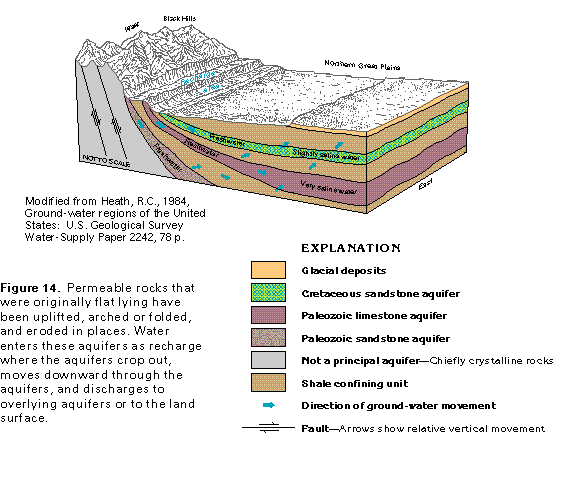
Aquifers and the Williston Basin
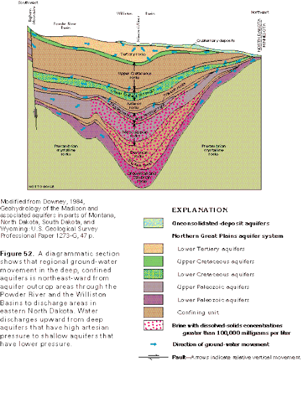
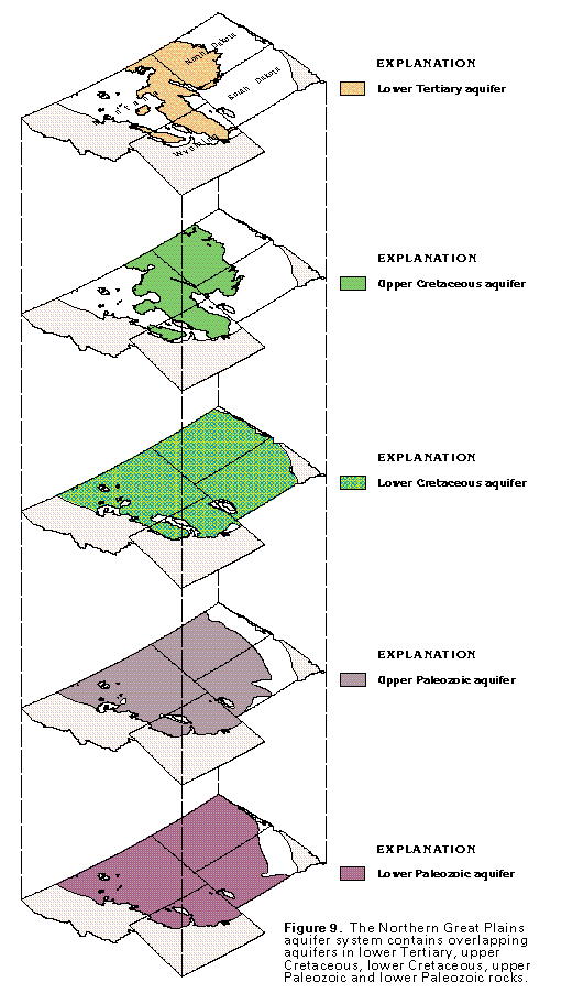
The Great Plains aquifers are divided into five regions with confining units between them. The Williston Basin is a deep depression underground and the aquifers are fed from the Rockies through what is called the "Montana Trough" into this region. The Majority of oil shale is located in the confining unit between the Paleozoic Aquifers. These aquifers have maintained a cool environment for this shale to remain in the confining units that would have otherwise naturally developed into liquid oil. Oil shale production simulates this natural process by increasing the heat gradients high enough to separate the kerogen from the shale.
|
|
Recharge
The spring brings about the melting of the snow-pack causing a "Recharge" event filling the aquifers. This cool water charges the aquifers driving the heated water up towards the surface. In July, after the melt is complete, there is a gradual heating event that naturally occurs as the aquifer levels naturally decline. Water flows from the mountains through the different layers charging the lower aquifers, which in turn drives the water upwards with pressure.
|
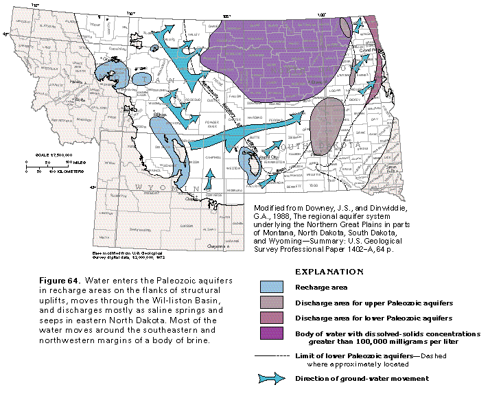
The Rocky Mountains charge these aquifer downhill into the Williston Basin and through the Montana Trough located in eastern Montana. If you reverse the direction of the arrows, this would be the direction of heated water and vapor. |
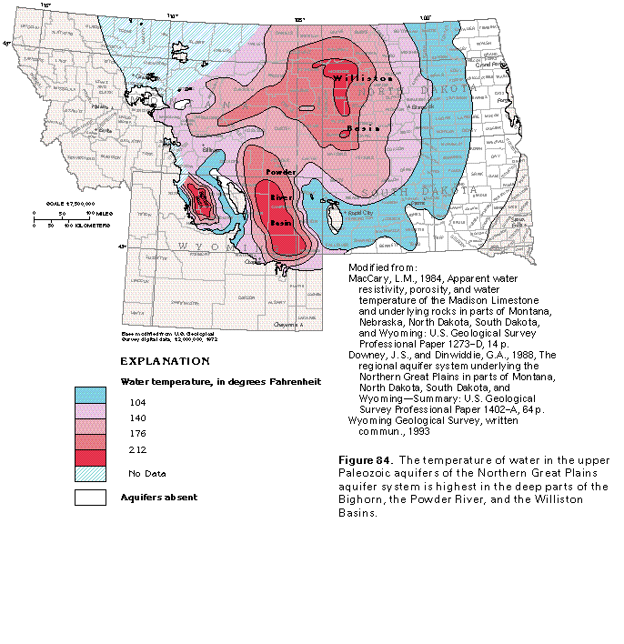
Natural Temperatures
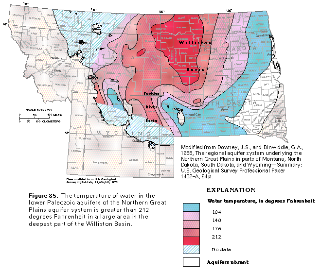
The highest concentration of oil shale is in between these two layers known as the Paleozoic Aquifers. As pressure increases so does the boiling point of water, and due to the deep water depression in this region, the temperatures also attain their highest levels. By heating these regions to 700F for over a decade, both of the Paleozoic aquifers in this region would now be vaporized. The temperature rise increase being injected is +488F.
|
|
Water and Heat Flow
Gravity controls the flow of liquid water while both heated water and water vapor opposes this force and rises. Heated vapor will naturally flow back up the aquifers that feed them, warming the surface waters as it rises to find an outlet, and this is also at higher elevations. This graph above demonstrates the aquifers near the surface and their feeds.
The primary feeds connecting the surface aquifers to the Bakken region is the Yellowstone and Missouri Rivers. 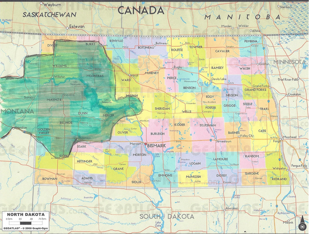
Using google maps I mapped out the regions found to be under oil production and highlighted it in green. Although they extend into Canada, our figures and calculations are limited to the US region alone. Current area under production in this region alone exceeds the size of the state of Maryland.
|
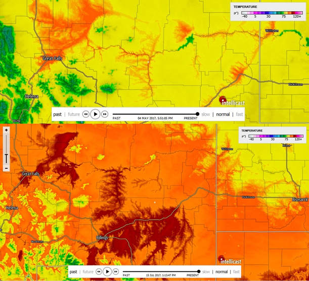
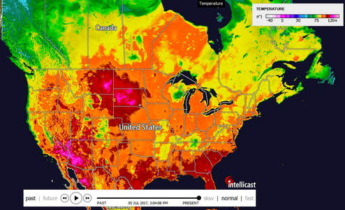
Here we see the temperature gradient on May 4, 2017 on the top, and today, July 15, 2017 on the bottom demonstrating the heat flow along the territorial aquifer fueling Great Falls and other region at higher elevations with a geothermal heat effect. This effect is natural and has resulted in regions like Great Falls (15F) and Billings, MT (18F) to attain an overall average low temperature in the month of January to be greater than regions at lower elevations. In contrast, Miles City, (9F) located along a river and Jordan, MT (4F) which is away from the rivers experience lower temperatures at lower in elevation. Temperature data link is available here.
Observation of the snow capped mountains on a nice warm day indicates that the temperature gradients decline with altitude. Additionally, the further you travel towards the equator, the warmer the temperatures become. Great Falls MT is 1,000' higher in elevation and 74 miles north of Miles City, MT, but averages 6F warmer. Great Falls is also 9F warmer than Jordan, MT, which is 6 miles south and 700' lower, but away from the rivers. This heating effect is a natural occurrence due to the aquifers. Today this natural heat effect is amplifying rapidly and flowing up into Montana through the Yellowstone and Missouri Rivers. 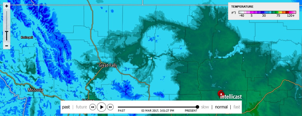
|