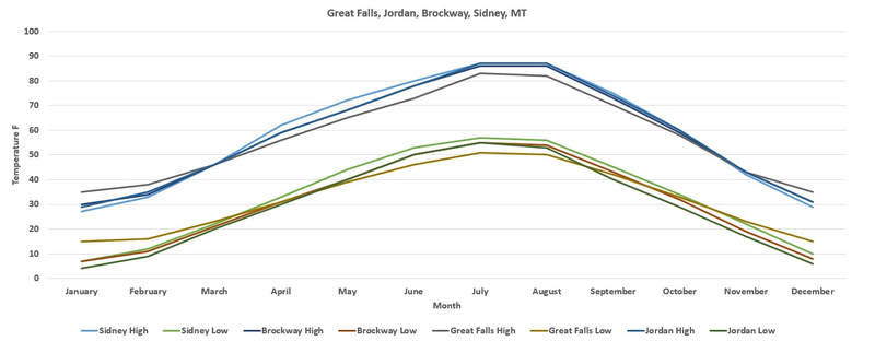
Using this climate data page, the following graphs were plotted. Every Spring the Rocky Mountain thaw and "Recharges" the subterranean aquifers flowing into the Great Plains aquifers. This is also termed, "The North American Monsoon Season." This recharge flushes cold water down into the aquifers cooling the subterranean during the summer while the surface heats. In mid to late summer this process ends and by fall the aquifers begin to warm. During the winter, while the surface cools, the aquifers supply warmth from below. This warming effect can be measured at various location along the Rocky Mountains where the source of this recharge begins. Wherever water can find a way into the aquifers in the spring, the heat, through water vapor, will rise back towards its source. In this graph we see Great Falls (3,300'), Brockway (2,682"), Sidney (1,949') and Jordan (2,602'), and all 4 locations are within 14 miles north or south of Great Falls. During the summer we see what we expect, as you rise in elevation the temperatures decline. In the fall we see a slow incline in temperatures at Great Falls that, by November, creates a natural warming effect in the region that lasts until March, when the next recharge begins. This is a natural geothermal effect that has naturally formed and developed over millions of years.
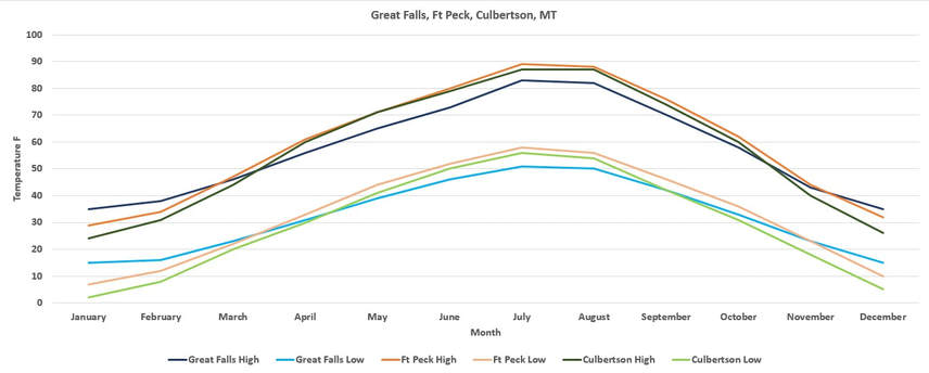
The Missouri River that flows through great Falls begins in the mountains and fed through multiple branching tributaries. Great Falls is at 3,300', and flows down to Ft. Peck at 2,178', and then to Culbertson, MT, at 1,932', This graph demonstrates that the further you are upstream, the warmer the surface temperatures naturally increase during the winters from this geothermal heating effect. Ft. Peck is 34 miles north of Great Falls, and Culbertson is 41 miles.
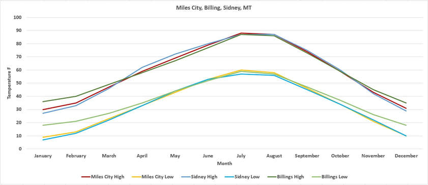
Another major branch feeding the Williston Basin is the Yellowstone River. From the mountains in Yellowstone, the river flows northeast and meets up with the Missouri River. The river flows through Billings, at 3,123', down to Miles City at 2,369' and then Sidney at 1,949'. Miles City is 55 miles, and Sidney 131 miles further north than Billings, that will result in a far less variation in temperatures in Billings compared to Great Falls. There is still a noticeable incline, specifically on the low temperatures at night when it deviates from the other two during the winters.
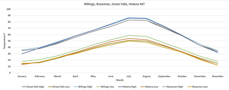
Here are the monthly averages for four cities in Montana, Great Falls, Billings, Helena, and Bozeman. Due to the mountains and uplifts between Great Falls and Helena, Helena is not affected by this heat effect to the levels measured in Great Falls. Bozeman, located at 4,793', is upstream from Billings and although it shows a warming effect, the high elevation begins to offset much of the heat gain. This heating effect occurs in many regions along the Rockies and around the world, the reason for understanding this process is to understand where the heat from oil shale will surface first.
This is just two of the primary feeds where the aquifers and land forms exchange not only water, but heat. Underground heating will follow upstream of its source and bleed into territorial aquifers, and then spread out over the region. Fueled by this exchange of energy, the source also acts as a vent for these regions.
Heating the shale to 700F, located between the Lower and Upper Paleozoic Aquifers, will have a massive impact on the surface over time and will bleed out in these regions prior to surfacing.
Heating the shale to 700F, located between the Lower and Upper Paleozoic Aquifers, will have a massive impact on the surface over time and will bleed out in these regions prior to surfacing.
|
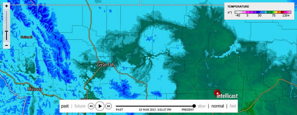
This image was taken on March 3, 2017 at 3:32pm. This demonstrates the heat flow traveling up the Missouri River that aids in the spring melt. When the melt begins, it cycles by melting and releasing massive amounts of cold water, cooling, and then reheating and melting again week after week until the snow pack is gone by mid summer. The melting snow in the spring, and the dew that occurs due to the altitudes and temperature deviations, continue to replenish the aquifers, but once the snow pack is gone the volume declines greatly.
|
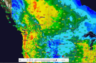
On April 18, 2016, the heat was rising just west of the Tar Sands operations in in Alberta, which is also at higher elevations. This heating preceded the Fort McMurray wildfires that began on May 1, 2016. Because heat cannot be created, there is a source for this heat and it's being generated at ground level.
|
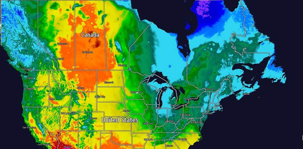
Four days after the Fort McMurray wildfire began, May 4, 2016, we can see this massive heat flux rise up between the Rocky Mountains and the Prairies. With the cold mountains to the west, the Arctic cold to the north and east, and cooler temperatures to the south, this heat is isolated from any external influence.
