Decoding Earth
  • Who We Are
  • How am I affected?
  • Store
  • Blog
  • Get In Touch
  • Data and Research
    • Heat source
    • Heat Discharge
    • Earth's Thermal Switch
    • Research and Analysis
    • U of M
    • Unveiling the Forest
    • Swan Lake
    • Heating Aquifers
    • Means of Measure
    • Conduction and Transpiration
    • Human Impact
    • Seasonal Impacts
    • Volcanic Seasons
    • Earthquake Cycles
    • Heat Flow
    • Global Dimming
    • Climate Change/Global Warming
    • Hurricanes, Typhoons and Cyclones
    • Water
    • Oceans >
      • Pacific Ocean
    • CO2 and its Cycles
    • Earths Magnetic Field
    • Oil Shale and Tar Sands >
      • Williston Geothermal Heat Effect
      • Bakken Shale
      • Stored Energy Calculations
    • Change
    • Human Population Growth
    • Sustainability
  • Oil production and Earthquakes
  • Downlaodable Files
  • Crop Blog
  • Serenegirl
  • Earth's Thermal Switch the Driving Force Behind Climate Change
  • Spirit of Hope for Women - Africa (SOHFA)
  • Profile

Pacific Equatorial Region

Picture
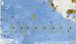
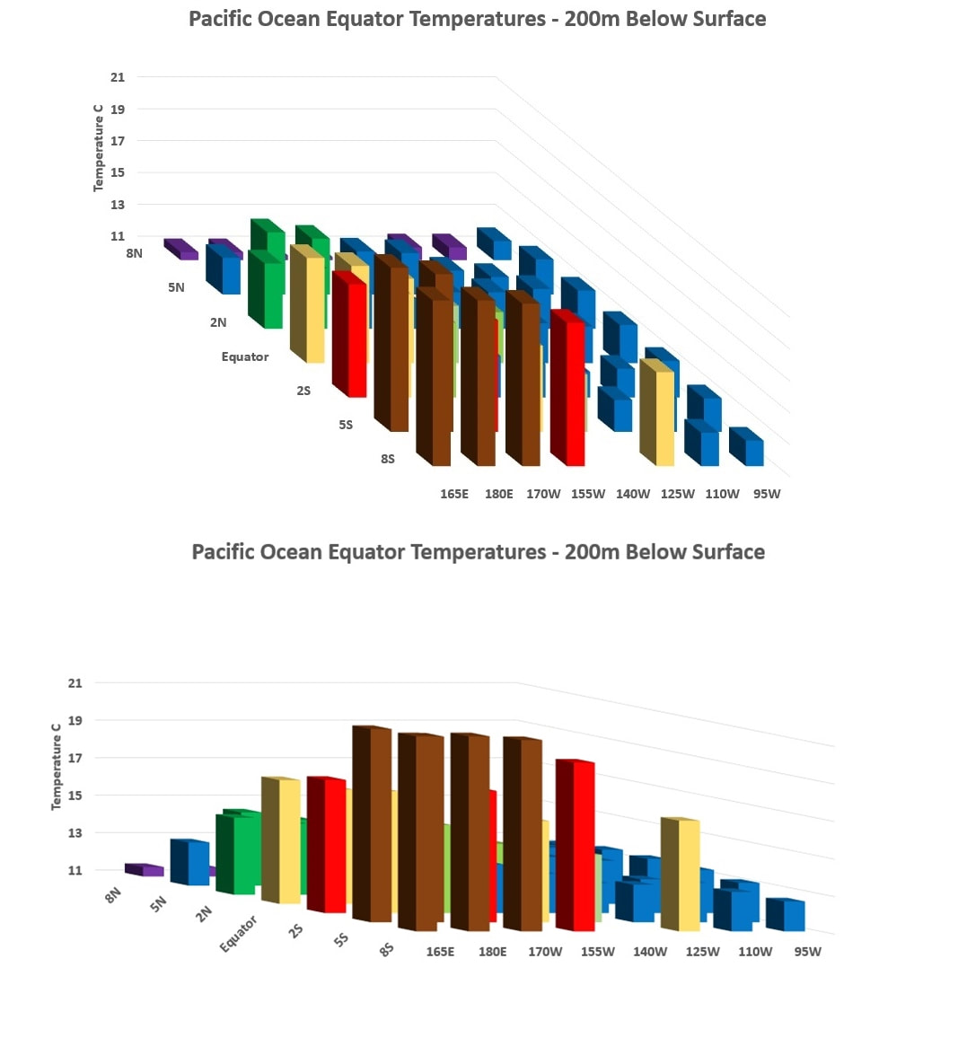
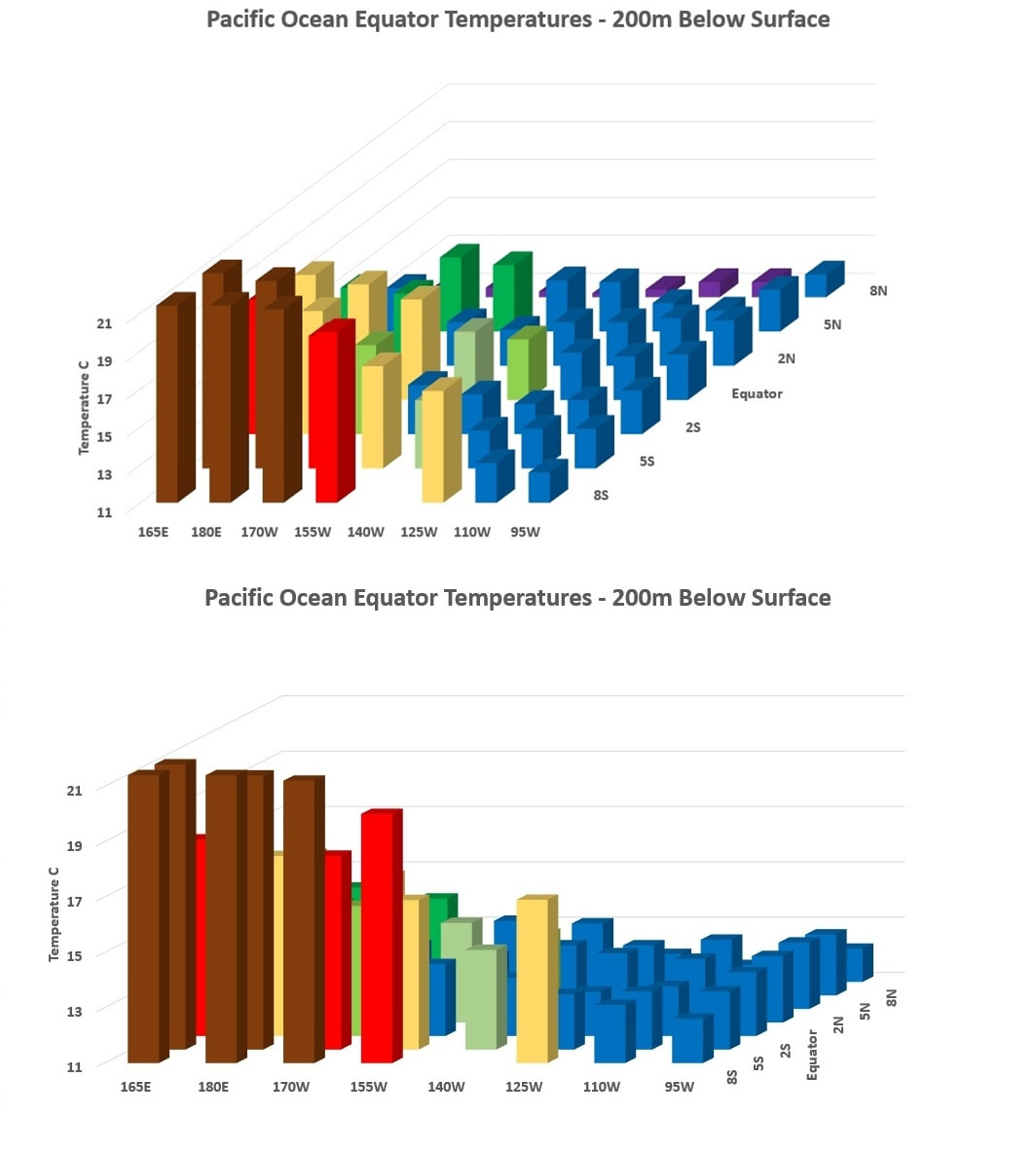
Across the Pacific there is a series of buoys that measure various meteorological measurements, including water temperatures down to 500 meters.  All buoys measure at 100, 300, and 500 meters in depth, but buoys 1 through 4 measure a depth of 200 meters and 5 through 8 measure it at 180 meters.  This variance will result in a slight increase in measurements at the 200 meter region in the following charts for buoys 5 through 8.   The sea surface temperatures are measured at 1 meter beneath the buoy, and the air temperature varies between 3 and 4 meters above the surface.  Annual sea surface temperatures always exceeded the average yearly air temperatures by 1 to 1.8C indicating that, even at sea, the heat flow is rising and warming the thermometer above the buoys with a measurable heat loss.

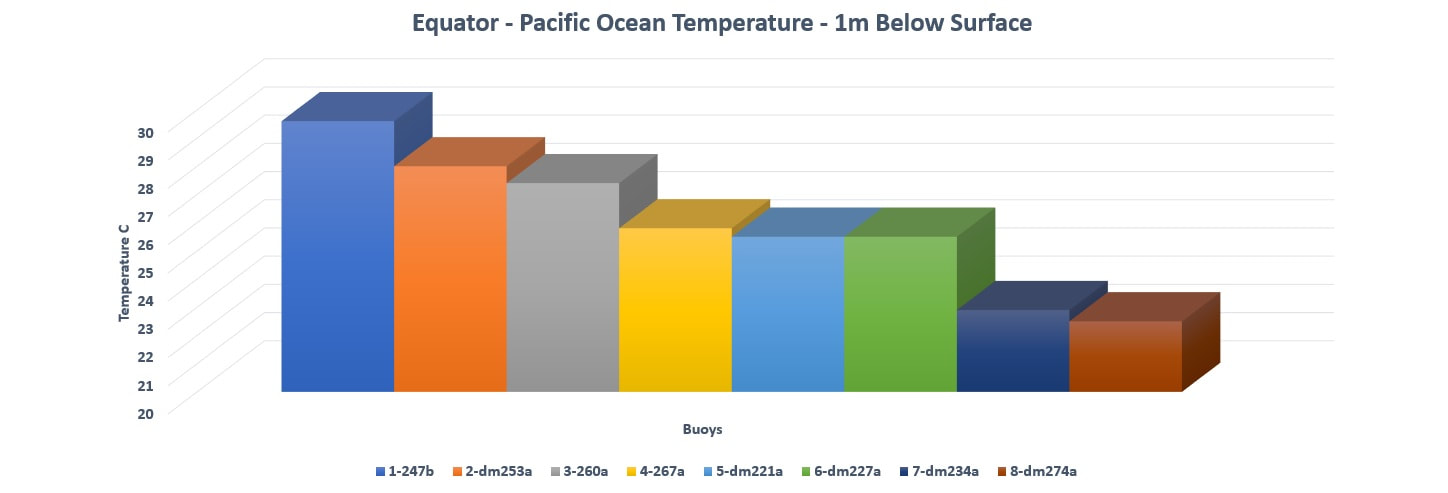
First analysis of this region revealed a variance in surface temperatures as we travel across the Pacific with the western Pacific being warmer than the East and flowing with the natural gravitational pull that moves our weather systems and tides.  If the sun was the dominate factor of heat for our oceans, then we would expect to see near equal temperatures across this region, but ocean currents can also create surface oscillations.
Picture

Picture


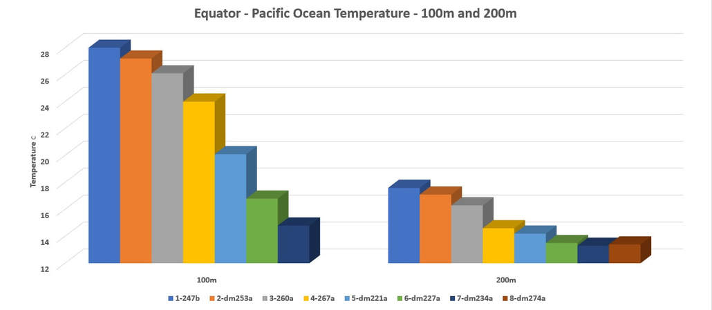
Researching the 100 and 200 meter depth we find an even larger deviations than the surface variance at 100 meters.  Each region across the Pacific receives the exact same amount of solar energy indicating that this thermal mass being measured is from geothermal heat. 

Picture


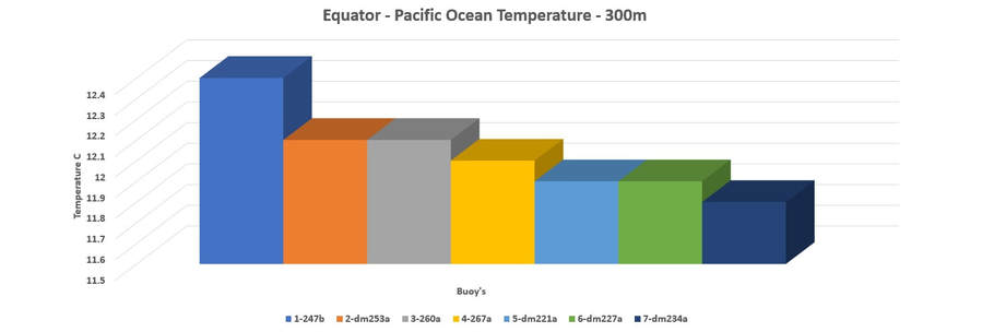
At 300 meters, as we descend beyond the influence of the solar energy, we see the variations continue but decline in amplitude. 

By isolating each buoy along the equator at the 200 meter depth, the heat source for the Pacific becomes identifiable.  The closer to the Australian plate, the warmer the waters become.  This brings us to regions such as the Solomon and Mariana Islands, New Guinea and New Zealand.  This region is known for their volcanic activity.
Picture
Picture
Picture


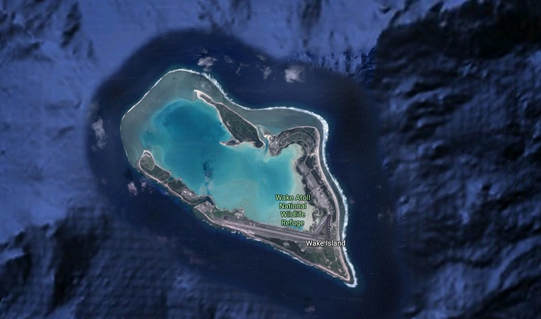
Islands in this region, such as Wake Island in this image, is an island that appeared and is actually the ridge that had built up over time and eventually protruded the surface.  Volcanoes are vents and even inactive volcanoes such as these will naturally generate an increase in heat flow.

What Can We Do?

"There are three primary factors which can help influence our environment for the betterment of future generations. First, we must educate our youth on the critical success factors to maintaining and improving our earths resources. Secondly, we must stop all shale production and all activity that heats the earth beneath us. Finally, we need to replant our earth and hold back the water that we currently allow to run off and find its way back to the sea. As the ultimate machine, our EARTH, was created to grow and evolve."

Contact Us

    Subscribe Today!

Submit
  • Who We Are
  • How am I affected?
  • Store
  • Blog
  • Get In Touch
  • Data and Research
    • Heat source
    • Heat Discharge
    • Earth's Thermal Switch
    • Research and Analysis
    • U of M
    • Unveiling the Forest
    • Swan Lake
    • Heating Aquifers
    • Means of Measure
    • Conduction and Transpiration
    • Human Impact
    • Seasonal Impacts
    • Volcanic Seasons
    • Earthquake Cycles
    • Heat Flow
    • Global Dimming
    • Climate Change/Global Warming
    • Hurricanes, Typhoons and Cyclones
    • Water
    • Oceans >
      • Pacific Ocean
    • CO2 and its Cycles
    • Earths Magnetic Field
    • Oil Shale and Tar Sands >
      • Williston Geothermal Heat Effect
      • Bakken Shale
      • Stored Energy Calculations
    • Change
    • Human Population Growth
    • Sustainability
  • Oil production and Earthquakes
  • Downlaodable Files
  • Crop Blog
  • Serenegirl
  • Earth's Thermal Switch the Driving Force Behind Climate Change
  • Spirit of Hope for Women - Africa (SOHFA)
  • Profile